
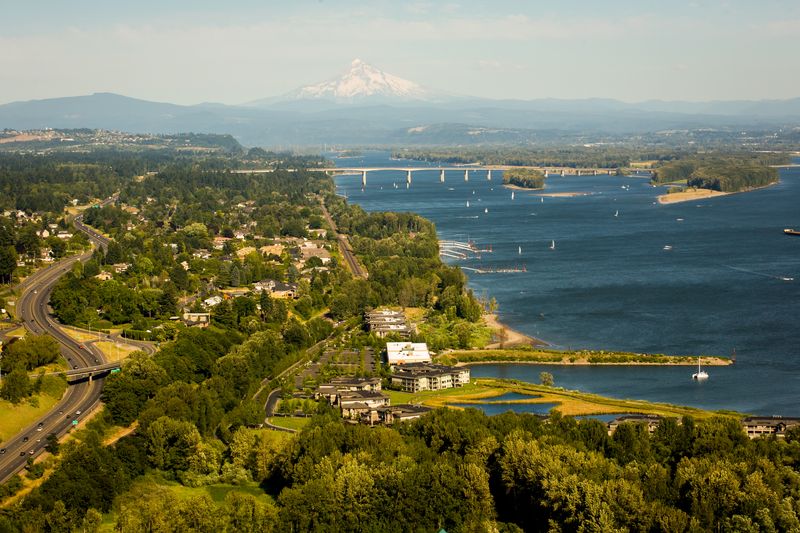
Caption: Columbia River waterfront looking east towards I-205 bridge and Mt hood.
Editor’s note:The City of Vancouver provided the following information on the Columbia River and Vancouver, Washington.
The mighty Columbia River waterway rolling along Vancouver’s southern shore is the largest river in the Pacific Northwest. With its headwaters rising from the Rocky Mountains in British Columbia, it travels more than 1,000 miles to its Pacific Ocean destination.
Vancouver plays a central role in the dynamic, ever-changing history of the Columbia. Native people flourished here for thousands of years on the plentiful bounty from the river and surrounding forests. American explorers Meriwether Lewis and William Clark camped at Cottonwood Beach just east of Vancouver in 1806. In 1825, Dr. John McLoughlin moved the Northwest headquarters of Hudson’s Bay Company from Astoria, Oregon to what is now the historic Fort Vancouver National Historic site. Fort Vancouver’s strategic location on the Columbia River served as the hub for Pacific Northwest fur trading.
In 1846, America’s borders were extended north to the 49th parallel, bringing Vancouver and the Northwest into the folds of United States. The City of Vancouver eventually incorporated in 1857 and eventually played a major role in the development of railroads, airplane and ship building and the continued restoration of Fort Vancouver National Park, Officer’s Row buildings, Fort Vancouver barracks and the oldest living apple tree in the Pacific Northwest dating back to 1825.
Today, Vancouver residents play, hike, swim and launch their boats along the Columbia’s many trails, parks and launching facilities. The City of Vancouver has also played the lead role in connecting its residents to the Columbia’s rich history. Projects such as the Columbia River Renaissance Trail, Water Resources Center and the planned 35-acre development just west of the I-5 Bridge are moving the city to a brighter future.
The Columbia River connects Vancouver and Clark County citizens to local recreational opportunities, evergreen forests, wildlife and miles of shoreline stretching from Steigerwald Lake National Wildlife Refuge to the east and Ridgefield National Wildlife Refuge to the west. Here are the highlights:
Gateway to Gorge
Steigerwald Lake National Wildlife Refuge: The 1,049-acre refuge serves as the gateway to the Columbia River Gorge National Scenic Area. Visitors can hike the Gibbons Creek Wildlife Art Trail to explore the historic riverine floodplain habitat, wildlife and remnant stands of Oregon white oak.
Marine Park: This 26-acre site offers walking trails, play equipment, picnic shelters, boat launch, and restrooms.
Wintler Community Park: Situated on the bank of the Columbia River, this 12.5-acre beach park has picnic tables, paved walkway, and a restroom.
Captain William Clark Park at Cottonwood Beach: Captain William Clark Park at Cottonwood Beach features water access, multi-use trails, restrooms, historic interpretive elements, picnic shelters and parking lots.
Water Resources Education Center: The Water Center brims with activities interactive exhibits, hands-on activities, aquaria swimming with fish, toddler-friendly Puddles Place, environmental artwork, natural gardens and wildlife-friendly wetlands.
Renaissance Trail
Waterfront Renaissance Trail: The five-mile trail takes hikers along the Water Resources Education Center, Marine Park, Kaiser Viewing Tower and Shipyards, Tidewater Cove and Wintler Park. Shops, restaurants and picnic areas dot the trail along the way.
Waterfront Park: The five-acre park features benches, great views of the Columbia River and the starting point for the Waterfront Renaissance Trail.
Old Apple Tree Park: Vancouver’s Old Apple Tree, planted in 1826 on Fort Vancouver, is the oldest apple tree in the Northwest.
Wendy Rose Sculpture: Wendy, dressed in work clothes and red glass polka dot scarp, is a stainless steel sculpture celebrate the spirit and legacy of the women of WWII. The head scarf was recently vandalized but replace thanks to a generous donation from Thompson Metal Fabricators.
Kaiser Viewing Towner and Shipyards: The memorial to the WWII era shipyard features a viewing tower overlooks the historical site of the former Kaiser Shipyards.
Columbia Springs: The public can visit this 100-acre site daily for visits to the historic Vancouver Trout Hatchery, urban natural area and walking trails.
Connecting to waterfront
Connecting to the Waterfront: Work is underway to reconnect downtown Vancouver with the Columbia River waterfront. Future development includes a 7-acre waterfront park, a pier, extension of the City’s popular Columbia River Renaissance Trail and a 35-acre mixed use development just south of downtown Vancouver.
Frenchman’s Bar Park: This lush 120-acre regional park features a 2.5 mile trail connecting to Vancouver Lake Park and a wide variety of outdoor recreation opportunities.
Ridgefield National Wildlife Refuge: Visitors to the 5,300-acre Ridgefield National Wildlife Refuge enjoy viewing waterfowl, shorebirds, raptors, river otter, black-tailed deer, coyotes, herons and numerous other species of wildlife…..just a few minutes from Vancouver.