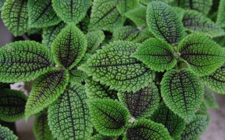
Gardeners and non-garden-types may be interested to learn that Crater Lake National Park in Central Oregon is a giant moss garden!
Yes, aquatic moss not only lives, but flourishes, in the incredibly cold and deep lake at depths from about 100 to 400 feet. Scientists are studying it and often use a deep-sea rover to “get the picture” and samples.
According to the National Park Service:
New information on moss distribution, biomass, and history in the lake is one of the most significant development in the ecology of Crater Lake in 40 years.
The moss is a type of bryophyte (Drepanocladus sp. and Fontinalis sp.)
The moss is most common around Wizard Island, but can be found around the margins of the entire lake
The moss grows at 25-140 meters
Field studies used remotely-operated vehicles (ROV), multi-beam sonar, side-scan sonar, and sonar back-scatter analyses to map the moss locations
Dead moss layers, underlying the live moss, have been dated at several thousand years old

This graph shows a cross-section of the bottom on the east side of Wizard Island, with the aquatic moss deposits shown by the arrows “Thick Peat Sediments” and “Fumaroles”. The thick peat sediments are remnants of dead moss that have accumulated over hundreds or thousands of years. Live moss (not shown) still live on the surfaces of some of the peat deposits. The fumaroles are curious pits, depressions, and tubes in some areas of the peat deposits.
A tunnel through dead aquatic moss at the bottom of Crater Lake. The dead moss layers accumulate over thousands of years, sometimes reaching 40 yards thick. Various pits, holes, and depressions form in the dead moss which vary in size from inches to tens of yards in diameter.
Scientists and biologists spent 20 days at Crater Lake during the summer of 1987 studying the chemistry, biology, hydrology, and geology of the bottom of the lake. The research group used various instruments including the rover vehicle pictured to the left.
Their findings are reported in this document, “Studies of Hydrothermal Processes in Crater Lake, OR” by Collier, Dymond, and McManus.
Visiting Crater Lake
For a brief time each year, Crater Lake National Park emerges from winter hibernation to bask in summertime glory. During this brief summertime window, one magnificent day typically follows another. For visitors, these few months provide the best opportunity for a comfortable visit.
Many interpretive programs are offered which encourage a deeper understanding of the lake and the park. Hiking and camping are popular activities. Fishing for trout and salmon in the lake is also a favorite pastime. Families find Crater Lake a wonderful cool place to reconnect with picnics and reunions. And for park staff, this short season provides the only access to numerous projects long buried under the snow.
This summer season is short (Crater Lake’s first snowfall is often in September) so viewing a dormant volcano with a magnificent blue lake within its crater is an experience not to be missed.
Please be aware that areas in and close to the park have little to no cell phone coverage. In planning your trip, also know that from November to May, there is no gasoline for sale in the park. The nearest gas stations are 35 miles away in the towns of Chiloquin and Prospect.
For GPS: The park has no physical address. The Steel Visitor Center (open year round) is at 42° 53′ 48.91″N 122° 08′ 03.08″W or you can enter “Crater Lake” as a town or waypoint.
Roads inside and close to the park are typical mountain roads with many curves and a number of drop-offs. Weather can change suddenly, with snowstorms even in August. Drive cautiously especially if you’re not used to mountain driving.
From the South (Year Round):
From Medford – Route 62 north and east to the park’s west entrance.
From Klamath Falls – Route 97 north to Route 62 north and west to the park’s south entrance.
From the North (Summer):
The park’s north entrance is closed in the winter and spring. Dates can vary, but typically the north entrance is closed from early November to June. Please call park dispatch for the latest road status (541)594-3000.
From Roseburg – Route 138 east to the park’s north entrance.
From Bend – Route 97 south to Route 138 west to the park’s north entrance.
From the North (Winter):
From Roseburg – Route 138 east to Route 230 south to Route 62 east to the park’s west entrance.
From Bend – Route 97 south to Route 62 north and west to the park’s south entrance.


